01. Playgrounds
Children are our future, so treat them well!
In the Val di Rabbi, we can offer them plenty of nature, fresh clean air and playgrounds which are lots of fun!


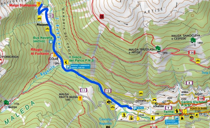
The starting point is the Plan car park, near Rabbi Fonti in the valley bottom, close to the cross-country skiing piste, around 800 m after the Terme di Rabbi spa. Continue straight on through the forest for around 500 m, cross the bridge over the Rabbies river and climb uphill on the southern bank to Colèr, close to Rifugio Al Fontanin. Take care on this section because it may be affected by avalanches. From the Rifugio, continue along the forest track to Malga Stablasolo. From here, you can continue to the bridge over the river with views of the Saènt waterfalls. Return by the same route.
Share
Rabbi Vacanze has launched a new rating system for holiday homes in the Val di Rabbi using ‘nests’. The aim is to provide full transparency about the information provided and the facilities on offer. Download the document to find out more about how they are graded.
Download the document to find out more about how they are graded.
Children are our future, so treat them well!
In the Val di Rabbi, we can offer them plenty of nature, fresh clean air and playgrounds which are lots of fun!

We sent you an email. To activate the newsletter click on the link you will find in the message, thank you!
Today
Min 4°C / Max 9°C
nubi sparse
Tomorrow
Min 1°C / Max 11°C
poco nuvoloso
Day after tomorrow
Min 5°C / Max 13°C
sereno